|
|
|||||||
              |
 |
||||||
Advice
for birders - In consultation with our research group,
the Florida Fish & Wildlife Conservation Commission decided not to
close any areas in the Choctawhatchee River Basin, including our
discovery and study area. Closing access to areas would
understandably anger local people who use the river for hunting and
fishing, and we want local people to be allies not adversaries.
At present, we are not releasing the specific location where we collected evidence for the presence of ivorybills in the Choctawhatchee River basin in 2005/2006 and where we will continue to systematically search in 2006/2007. If you learn of the location of our study area, please do not pass it to other ivorybill enthusiasts and certainly do not post it on the web. Even though no areas will be officially closed, we ask that no woodpecker seekers enter our study area. We will be using remote sound monitoring stations in this area in attempt to document the presence of ivorybills, and we will have a small team of searchers engaged in a systematic search for roost and nest cavities. Intrusions by birders will hinder these activities making it harder for us to gather definitive proof that ivorybills persist in this river basin. If we encounter birders in our study area, we will ask them to leave and suggest other areas to search. It is not worth endangering this small population of Ivory-billed Woodpeckers to try to get this bird on your life list. Our observations of bark scaling and large cavities from I-10 to the Choctawhatchee Bay suggest that ivorybills may be widespread in the Choctawhatchee River Basin, and there are many areas to explore outside of our small study area with great potential for ivorybills. Below, we suggest several places to search. If birders spread out, the impact on any given area will be small. If birders crowd into one spot, ivorybills will be driven out of that area. We ask that you put the interest of the bird first. We also ask that you do not mimic the sounds of Ivory-billed Woodpeckers anywhere in the Choctawhatchee River Basin. There is no evidence that mimicking ivorybills will increase your chances of seeing one, but having birders in the area playing tapes will certainly diminish the outdoor experience of other bird watchers. If you hear a kent call or double knock in this swamp, you want to be confident that it is not coming out of the tape recorder of another birder. |
 |
||||||
| Suggested
areas to search for Ivorybills -The Choctawhatchee River
Basin is not a birder-friendly area. There are few motel rooms
and only a couple of small restaurants in the entire region. The
Choctawhatchee River bottomlands have no walking trails or canoe
trails. There are no information centers, observation towers, or
even signs on most of the dirt roads in the area. For anyone
venturing off roads and especially venturing forth in a canoe or kayak,
we strongly recommend that you get topo maps of the area and carry a
GPS. The DeLorme Atlas of Florida is helpful for finding road
routes but is useless for details of the river and swamp. It is easy to
get lost, and swift currents and many submerged logs make boating
dangerous. Poisonous snakes including water moccasins and two species
of rattlesnakes are common, as are alligators. There are many
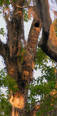
feral pigs and a few bears in the forest. Places to search For walkers/casual boaters 1. Tilley Landing. A gravel road runs from Highway 81 east into mature swamp forest ending at two small canoe launches that feed into Lost Lake, a beautiful oxbow lake. This area has numerous large cavities and scaled trees, including feeding sign on spruce pine along the road, suggesting that it is regularly used by Ivory-billed Woodpeckers. Walking the gravel road from the upper parking area (at the Choctawhatchee Wildlife Area sign) to the end of the road is an excellent way for birders who do not want to kayak or wade to search for ivorybills. This road first skirts the edge of the swamp forest with pine plantation on the left but then plunges into maturing swamp forest. For the novice kayaker or canoeist, touring Lost Lake is a fairly safe means to paddle around in the swamp in an area that may have ivorybills. Do not venture beyond the lake into the flooded forest unless you are competent with your boat and a GPS. Lost Lake lies in a large swamp forest, and it is easy to get lost when the forest is flooded. The three parking lots here that can accommodate many automobiles. For Kayakers and canoeists (and motor boaters) 2. Dead River Landing. This is a favorite place for local folks to launch boats and camp. The waterways around the landing have huge cypress and the forests in this area are mature. It is very easy to get lost if you venture out in a boat in this area so bring a map and a GPS. Both feeding sign and large cavities suggest ivorybill activity in this area. The parking lot can accommodate about 20 cars. 3. Lower Holmes Creek and the Boynton Cutoff. At the end of Road 284A on the east side of the Choctawhatchee River are two access points. Shell Landing provides access to Holmes Creek about one mile above where it meets the Boynton Cutoff (which carries more water than the channel officially called the Choctawhatchee River). South of the end of this road is a dirt road leading to a boat ramp on the Boynton Cutoff. There are many large cypress and mature hardwood forests in this area with lots of potential Ivory-billed Woodpecker sign. The river and creek here can be swift and dangerous. Note that contrary to what is shown in the DeLorme atlas, 284A does not cross Holmes Creek. 4. Cedar Tree Landing and Rocky Landing. These landings are off of HWY 79 on the east side of the river. Habitat at these landings is marginal but directly across the river is nice forest with high ivorybill potential. 5. Reason Lakes. There is a large boat ramp on the west bank of the Choctawhatchee River where Highway 20 crosses it. To move from the boat launch to the lakes paddle south for a hundred yards or so then turn north and move up an eastern channel under the highway then paddle back south along an even more easterly channel, back under the highway and into the Reason Lakes area. The tupelo and cypress in this area are impressive with interspersed hammocks of oak, sweetgum, and spruce pine. Many large cavities and scaled trees suggest that ivorybills regularly use this area. This is one of the most scenic areas along the river. It is very easy to get lost in this maze of oxbow lakes and dry ground. 6. Smokehouse Lake Road. Off county road 3280 south of the town of Bruce. At the end of Smokehouse Lake Road is a small landing where boats can be launched for a $3 fee. The areas west of this landing are among the most remote and wild in the entire basin, and this is an area with abundant sign of ivorybills. 7. East River and East River Island. There is limited access to this vast swamp wilderness. Only physically fit, experienced kayakers or canoeists with good abilities to navigate in remote areas should enter this area. Much of the 10 square miles of forest on East River Island is mature oak, tupelo, and spruce pine with scattered huge cypress. The island has no roads or trails. Rolek and Hill observed abundant evidence of ivorybills in this area. For the true swamp experience and for the greatest chance of seeing or hearing ivorybills, East River is hard to beat. |
|||||||
 |
 |
 |
|
|
|
|
|
| Back to the top | |||||||
 |
|||||||
 |
|
 |
|
 |
|||
|
|
|
|
|
|
|
|
|
All information on this website is
copyright Daniel Mennill.
No information on this page may used without explicit permission (dmennillATuwindsorDOTca). |
|||||||