Detroit River-Western Lake Erie Basin Indicator Project
Hexagenia Density and Distribution in the Detroit River
Background
Many types of habitats for aquatic invertebrates exist in the Detroit River as a result of the current and its effects on the river bottom. Since each species requires a particular habitat, certain ones should exist at a given place and others should not, based solely on habitat type. Therefore, care must be taken when evaluating the health of the benthic community since the absence of a species may not be an indicator of pollution problems.
Currents in the main part of the river wash away fine sediments, leaving a substrate composed mainly of stones and hard clay (erosional areas). Some animals can shelter beneath or between the stones, but the most abundant species in this type of habitat can attach themselves to the substrate or build shelters for themselves (e.g., net-spinning caddisflies, limpets, dreissenid mussels, flatworms).
Slower-flowing parts of the Detroit River (depositional areas) have a muddy or sandy bottom. These are also the areas where debris carried from upstream settles out. The benthic animals living here burrow into the mud and feed upon the organic debris and the attached bacteria and fungi present in the sediments. When the organic content of the sediments is high, bacterial respiration can remove much of the oxygen from the water, making the habitat suitable only for species with a tolerance to low oxygen levels. These are also regions where pollutants that aren't water soluble tend to collect. Because oils and trace amounts of metals adhere to the organic matter in the mud, the zoobenthos of depositional zones tend to ingest and carry these materials from their food at a more concentrated level than is present in their surrounding environment.
The most common benthic animals living in depositional zones are worms (Oligochaeta), midge larvae (Chironomidae), and Hexagenia mayfly nymphs (Ephemeroptera) (Figure 1). Hexagenia is a dominant component of the benthic fauna of muddy and silty sediments in mesotrophic (intermediate level of productivity) lakes and rivers. Historically, Hexagenia mayflies were abundant throughout the Huron-Erie Corridor and the western basin of Lake Erie. Mayfly nymphs dig U-shaped burrows. They undulate their abdomen and wave their feather-like gills which forces oxygen-rich water through the burrow. Because mayflies can't survive in water that lacks oxygen, they are good indicators of the amount of organic pollution (e.g., sewage). For example, when water quality conditions are good, one expects to find 100 Hexagenia larvae per square meter or more in clean muddy sediments of Lake Erie (Wright and Tidd 1933). Researchers have proposed Hexagenia mayflies as an ecosystem indicator of mesotrophic conditions in soft-sediment habitats of the Great Lakes (Reynoldson et al. 1989). The Ohio Lake Erie Commission's (2004) Hexagenia index classifies conditions as excellent where sediments contain 200-300 larvae per square meter. Areas dominated by worms and midges, rather than mayflies, are classed as having degraded water quality or benthic conditions.

Figure 1. Oligochaete with setae visible. Oligochaetes typically have four pairs of setae (chaetae) per segment which are used during burrowing and crawling movements (Photo credit: USGS, Great Lakes Science Center).
Thornley and Hamdy (1984), Hudson et al. (1986), Manny et al. (1988) and Farara and Burt (1993) all reported Hexagenia as an indicator of relatively undegraded benthic conditions in the soft sediments of the Detroit River. Hexagenia densities of less than 20 per square meter in depositional habitats suggest degradation (Thornley and Hamdy 1984; Ciborowski 2003b). However, Edsall et al. (2001) reported that Hexagenia production (i.e., a combined estimate of growth and abundance) was a more sensitive indicator of suitable ecological conditions than density alone.
Status and Trends
Larval Distribution
Some of the earliest Great Lakes zoobenthos surveys were conducted in 1929-1930 by Wright and Tidd (1933) in western Lake Erie and at the mouth of the Detroit River, as well as other Lake Erie tributaries. Among other zoobenthos, they reported snails, fingernail clams, and worms. However, mayfly larvae were conspicuously absent, indicating light to moderate pollution at the Detroit River mouth.The Trenton Channel has long been identified as a degraded area based on zoobenthos composition and abundance. Surveys conducted between 1949 and 1956 showed that the lower Detroit River and the western Trenton Channel were dominated by pollution-tolerant forms, indicating a decrease in water quality from the 1929-1930 surveys. Carr and Hiltunen (1965) showed that the spatial extent and severity of degradation at the mouth of the Detroit River had increased substantially from that described by Wright and Tidd (1933). Later surveys reported that although the Detroit River mouth contained only very pollution-tolerant organisms (worms and leeches), zoobenthos composition and abundance upstream of Belle Isle was indicative of good water quality (Vaughan and Harlow 1965).
Several surveys of the bottom fauna of the Detroit River were conducted between the 1960s and 1990 (Thornley 1985; Hudson et al. 1986; Ferrara and Burt 1993). In 1968, the bottom fauna over large tracts of the Detroit River suggested that sediments and water quality were degraded. Mayflies were found in only about 25% of the locations sampled, and then only in low numbers (10-20 per square meter; Thornley and Hamdy 1984). Mayflies were completely absent from the United States shoreline except near the upstream end of Belle Isle (Figure 2). Almost no zoobenthos could be found in the vicinity of Zug Island.
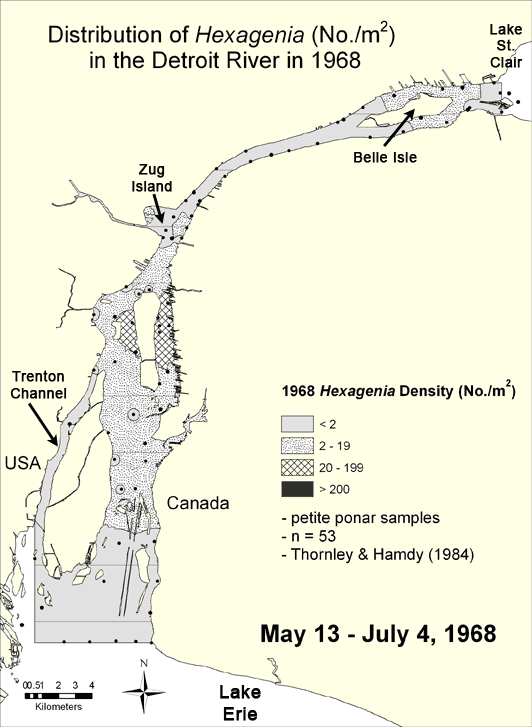
Figure 2. Density of Hexagenia in the Detroit River in 1968 interpolated from data compiled from Thornley and Hamdy (1984). Areas containing fewer than 20 nymphs/m2 indicate either degraded benthic conditions (if sediments are soft) or unsuitable habitat for mayflies (if sediments are hard). Map by Anita Kirkpatrick. Click here for a larger map.
Pollution controls put in place during the 1970s resulted in improved water and sediment quality in many areas. When the river was surveyed again in 1980, mayflies were found at over 70% of the locations examined, and they were 5 times more abundant than in 1968 (Thornley 1985; Figure 3). Densities exceeded 20 per square meter in both the upper and lower reaches of the Detroit River, being absent mainly south of Zug Island and in the Trenton Channel.
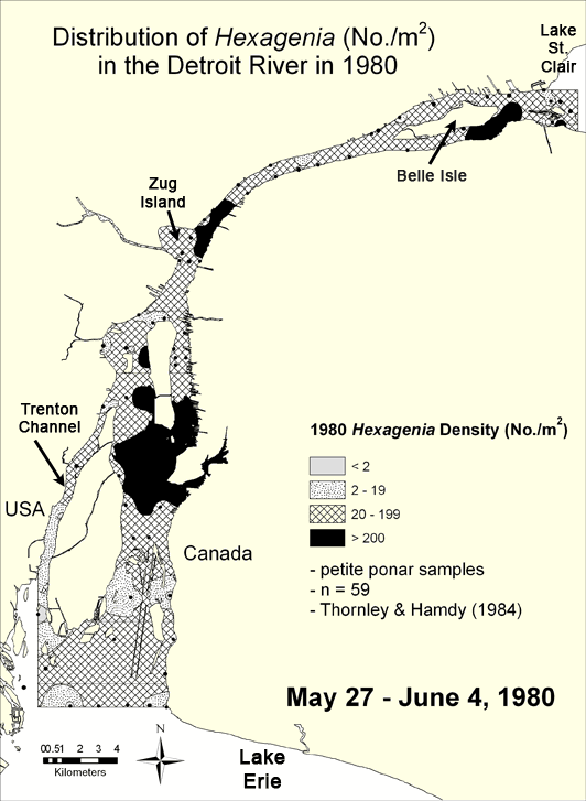
Figure 3. Density of Hexagenia in the Detroit River in 1980 interpolated from data compiled from Thornley and Hamdy (1984). Areas containing fewer than 20 nymphs per square meter indicate either degraded benthic conditions (if sediments are soft) or unsuitable habitat for mayflies (if sediments are hard). Map by Anita Kirkpatrick. Click here for a larger map.
Few changes in either the distribution or abundance of mayfly nymphs were seen between the 1980 survey, a 1983 investigation (Hudson et al. 1986), and a study done in 1991 (Farara and Burt 1993). In 1991, Hexagenia mayflies were found at about 60% of locations sampled, at densities of between 8 and 100 nymphs per square meter (Figure 4). However, more of the river supported densities slightly less than the 20 per square meter criterion suggested to indicate impairment (Ciborowski 2003b) than had been observed in 1980. Worms and midges remained the most common invertebrates along the United States shoreline of the river downstream from Zug Island.
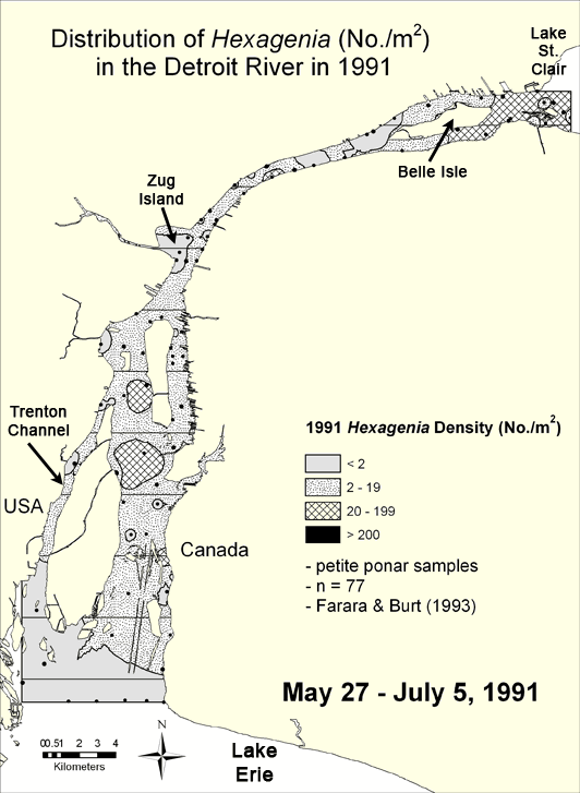
Figure 4. Density of Hexagenia in the Detroit River in 1991 interpolated from data compiled from Farara and Burt (1993). Areas containing fewer than 20 nymphs per square meter indicate either degraded benthic conditions (if sediments are soft) or unsuitable habitat for mayflies (if sediments are hard). Map by Anita Kirkpatrick. Click here for a larger map.
Little benthic sampling was conducted in the Detroit River through most of the 1990s, so information on health of the zoobenthic community during this time is scarce. However, the flying adult stages of Hexagenia and other aquatic insects became more numerous along both the Canadian and United States sides of the river and along the shores of Lake Erie (Ciborowski and Corkum 1988; Kovats 1990; Kovats et al. 1996; Corkum et al. 1997) suggesting that some improvements in river condition had been occurring.
The Detroit River was next intensively studied in 1999. Samples were collected from almost 150 locations (Wood 2004; Figure 5). Densities exceeded the 20 nymph per square meter impairment threshold at the head of the river and on the Canadian side of the lower reaches. Few nymphs were collected in the midreaches, however.
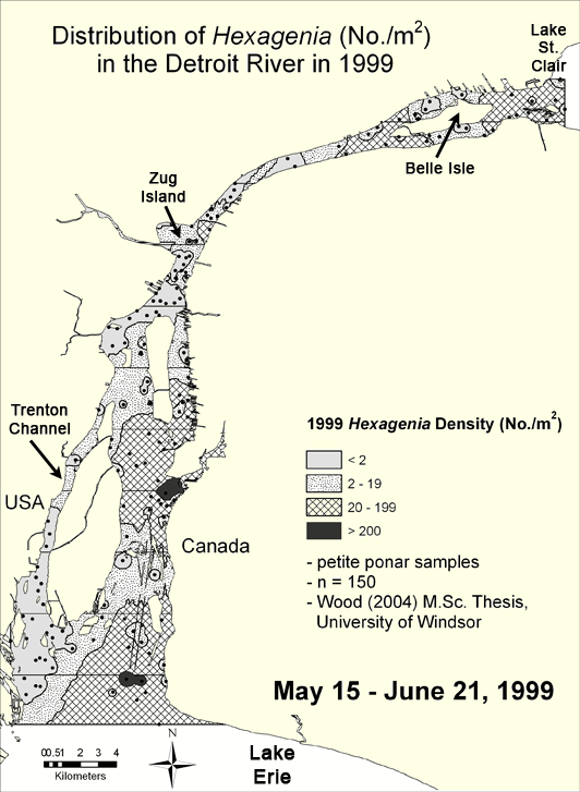
Figure 5. Density of Hexagenia in the Detroit River in 1999 interpolated from data compiled from Wood (2004). Areas containing fewer than 20 nymphs per square meter indicate either degraded benthic conditions (if sediments are soft) or unsuitable habitat for mayflies (if sediments are hard). Map by Anita Kirkpatrick. Click here for a larger map.
The entire Huron-Erie Corridor was sampled in 2004. A suite of 20 randomly-selected locations sampled in July and August 2004 produced a distributional pattern similar to that observed in 1968 (Ciborowski et al. 2006; Figure 6). However, this was partly due to the timing of sampling. In 2004, many samples were collected in July after the period of maximum emergence, but before nymphs representing the next generation had hatched from their eggs. Densities were moderate or high in much of Lake St. Clair and lower reaches of the St. Clair River (Figure 7).
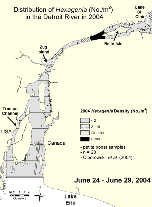
Figure 6. Density of Hexagenia in the Detroit River in 2004 interpolated from data compiled from Ciborowski et al. (2006). Areas containing fewer than 20 nymphs per square meter indicate either degraded benthic conditions (if sediments are soft) or unsuitable habitat for mayflies (if sediments are hard). Map by Anita Kirkpatrick. Click here for a larger map.
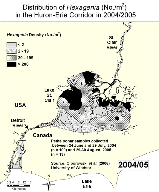
Figure 7. Density of Hexagenia in the Huron-Erie Corridor in 2004/05 interpolated from data compiled from Ciborowski et al. (2006). Areas containing fewer than 20 nymphs per square meter indicate either degraded benthic conditions (if sediments are soft) or unsuitable habitat for mayflies (if sediments are hard). Map by Anita Kirkpatrick. Click here for a larger map.
Riverwide Frequency and Abundance
Figure 8 summarizes the trends in Hexagenia abundance average across all samples for surveys conducted since 1968. Hexagenia mayfly nymphs were found in 70% of the 59 stations sampled in 1980 compared to only 26% of 53 stations in 1968 (Thornley and Hamdy 1984). The greatest changes in occurrence were along the Canadian shoreline. The mean density of Hexagenia in 2004 was 20 per square meter, but distribution was restricted to fewer locations than previously (Ciborowski et al. 2006), partly due to timing of sampling, as indicated above.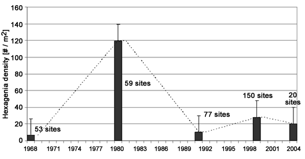
Figure 8. Mean ±SE density of Hexagenia in the Detroit River between 1968 and 2004. The number of sites sampled each year is indicated. *Data compiled from Thornley and Hamdy (1984), Farara and Burt (1993), Wood (2004), and Ciborowski et al. (2006).
Adult Abundance and Contaminant Burdens
Improvements in Detroit River water quality have been most obviously shown in the numbers of night-flying insects that are attracted to streetlights and storefronts along the river during warm summer evenings. Both Hexagenia mayflies and moth-like caddisflies emerge from the river in summer to mate and lay their eggs. Emerging Hexagenia (commonly called fishflies or June bugs) are most abundant for a few weeks from the middle of June until mid-July. Strong winds can carry the insects long distances inland from the river, but typically, most travel only a few hundred meters (Kovats et al. 1996).The insects are an important food for birds and fishes during their emergence period. They also provide a valuable tool for monitoring contaminant levels in the river. On a warm evening, a black light placed beside the river will quickly attract enough insects to provide a sample that can be analyzed for PCBs, heavy metals, and other pollutants associated with contaminated sediments (Corkum et al. 1995). Ciborowski and Corkum (1988), Kovats (1990), and Corkum et al. (1997) analyzed organic contaminant burdens in Hexagenia mayflies emerging at the head of the Detroit River near Peche Island. Concentrations of PCBs, pesticides, and other organochlorine compounds were virtually identical in 1986, 1989, and 1994. Yet, the numbers of emerging insects, and their distribution along the river, have continued to increase through the 1990s (Corkum et al. 1997).
Contaminant burdens (PCBs, pesticides, and other organochlorine compounds) of Hexagenia adults collected from shorelines of western Lake Erie in 1994 were elevated relative to collections made in offshore areas. Adults collected from Monroe, Michigan, adjacent to the mouth of the Detroit River had the highest burdens of organochlorine compounds of any samples. Burdens of trace metals were not unduly elevated. Hexagenia larvae collected from the vicinity of Middle Sister Island in western Lake Erie had high burdens of organochlorine compounds and polycyclic aromatic hydrocarbons (Corkum et al. 1997).
Management Next Steps
The available data show which portions of the river have historically been most heavily degraded by organic enrichment and those that are still affected by nutrient-rich water, primarily sewage and stormwater. The present-day distribution of Hexagenia nymphs suggests that current sediment and water quality conditions have not improved enough to permit nymphs to develop in those degraded areas. However, surveys have been conducted too infrequently to permit us to ascertain the extent to which year-to-year variation in distribution reflects changing pollution status vs. normal fluctuations in the mayfly population. Continued attention to point sources of pollution will be necessary to permit Hexagenia to populate all of the depositional habitats in the Detroit River.
Research/Monitoring Needs
Hexagenia surveys have been conducted too infrequently to permit one to ascertain whether the time trend patterns represent changing environmental conditions or random interannual variation. Ideally, sampling should be conducted yearly, and surveys should be completed in the spring, prior to the period of adult emergence (ideally during the months of April and May). Sampling methods (collection times, determination of site locations, number of sites sampled) should be standardized across years to improve the precision of riverwide density estimates.
References
- Carr, J.F., and J.K. Hiltunen. 1965. Changes in the bottom fauna of western Lake Erie from 1930 to 1961. Limnology and Oceanography 10:551-569.
- Ciborowski, J.J.H., and L.D. Corkum. 1988. Organic contaminants in adult aquatic insects of the St. Clair and Detroit Rivers, Ontario, Canada. Journal of Great Lakes Research 14:148-156.
- Ciborowski, J.J.H. 2003a. Lessons from sentinel invertebrates: Mayflies and other species. In Honoring Our Detroit River: Caring for Our Home, ed. John H. Hartig, pp. 107-120. Bloomfield Hills, MI: Cranbrook Institute of Science.
- Ciborowski, J.J.H. 2003b. Technical comments on delisting criteria for the Detroit River area of concern – Beneficial use impairment #6: Degradation of Benthos. In Workshop on Delisting Criteria for the Detroit River Area of Concern,Windsor, ON, eds. D. Dolan and P. Murray, pp. 78-87. April 26-27, 2002. Prep. for Detroit River Canadian Cleanup Committee.
- Ciborowski, J.J.H., J. Zhang, J. Baillargeon, and A. Kirkpatrick. 2006. Section 6 – Zoobenthos. Benthos and sediment chemistry studies on the Detroit and St. Clair rivers.InGreat Lakes Institute for Environmental Research et al. Draft report prepared for Great Lakes Sustainability Fund.
- Corkum, L.D., J.J.H. Ciborowski, and Z.E. Kovats. 1995. Aquatic insects as biomonitors of ecosystem health in the Great Lakes area of concern. In Biomonitors and Biomarkers as Indicators of Environmental Change: A Handbook, eds. F.M. Butterworth, L.D. Corkum, and L.J. Guzmán-Rincón, pp. 31-44. New York: Plenum Publishing Company.
- Corkum, L.D., J.J.H. Ciborowski, and R. Lazar. 1997. The distribution and contaminant burdens of adults of the burrowing mayfly, Hexagenia in Lake Erie. Journal of Great Lakes Research 23:383-390.
- Edsall, T.A, R.C. Haas, and J.V. Adams. 2001. Annual production of burrowing mayfly nymphs (Hexagenia spp.) in U.S. waters of Lake St. Clair. Journal of Great Lakes Research 27:449-456.
- Farara, D.G., and A.G. Burt. 1993. Environmental assessment of Detroit River sediments and benthic macroinvertebrate communities –1991. Report prepared for the Ontario Ministry of Environment and Energy by Beak Consultants Limited, Brampton, Ontario. Volume I.
- Hudson, P.L., B.M. Davis, S.J. Nichols, and C.M. Tomcko. 1986. Environmental studies of macrozoobenthos, aquatic macrophytes, and juvenile fishes in the St. Clair-Detroit River system, 1983-1984. U.S. Fish and Wildlife Service, Great Lakes Fish Lab, Administrative Report No. 86-7. Ann Arbor, MI.
- Kovats, Z.E. 1990. Adult aquatic insects as biomonitors of organochlorine contamination in freshwater habitats. M.Sc. Thesis, University of Windsor, Ontario, Canada.
- Kovats, Z.E., J.J.H. Ciborowski, and L.D. Corkum. 1996. Inland dispersal of adult aquatic insects. Freshwater Biology 36:265-276.
- Manny, B.A., T.A. Edsall, and E. Jaworski. 1988. The Detroit River, Michigan: An ecological profile. U.S. Fish and Wildlife Service Biological Report 85 (7.17). Ann Arbor, MI.
- Ohio Lake Erie Commission. 2004. State of the Lake Report, 2004. Toledo, OH.
- Reynoldson, T.B., D.W. Schloesser, and B.A. Manny. 1989. Development of a benthic invertebrate objective for mesotrophic Great Lakes waters. Journal of Great Lakes Research 15(4):669-686.
- Thornley, S., and Y. Hamdy. 1984. An assessment of bottom fauna and sediments of the Detroit River. Ontario Ministry of Environment Report, Toronto, Ontario, Canada.
- Thornley, S. 1985. Macrozoobenthos of the Detroit and St. Clair rivers with comparison to neighboring waters. Journal of Great Lakes Research 11:290-296.
- Vaughan, R.D., and G.L. Harlow. 1965. Report on pollution of Detroit River, Michigan waters of Lake Erie, and their tributaries. U.S. Department of Health, Education, and Welfare, Public Health Service, Division of Water Supply and Pollution Control. U.S. Government Printing Office, Washington, DC.
- Wood, S. 2004. The use of benthic macroinvertebrate community composition as a measure of contaminant induced stress in the sediments of the Detroit River. M.Sc. Thesis, University of Windsor, Ontario.
- Wright, S., and W.M. Tidd. 1933. Summary of limnological investigations in western Lake Erie in 1929 and 1930. Transactions of the American Fisheries Society 63:271-285.
Contact Information regarding Hexagenia Density and Distribution in the Detroit River
Dr. Jan Ciborowski
Department of Biological SciencesUniversity of Windsor
E-mail: cibor@uwindsor.ca