Detroit River-Western Lake Erie Basin Indicator Project
Hexagenia Density and Distribution in the Detroit River
Larval Distribution, 1980
Several surveys of the bottom fauna of the Detroit River were conducted between the 1960s and 1990 (Thornley 1985; Hudson et al. 1986; Ferrara and Burt 1993). In 1968, the bottom fauna over large tracts of the Detroit River suggested that sediments and water quality were degraded. Mayflies were found in only about 25% of the locations sampled, and then only in low numbers (10-20 per square meter; Thornley and Hamdy 1984). Mayflies were completely absent from the United States shoreline except near the upstream end of Belle Isle (Figure 2). Almost no zoobenthos could be found in the vicinity of Zug Island.
Pollution controls put in place during the 1970s resulted in improved water and sediment quality in many areas. When the river was surveyed again in 1980, mayflies were found at over 70% of the locations examined, and they were 5 times more abundant than in 1968 (Thornley 1985; Figure 3). Densities exceeded 20 per square meter in both the upper and lower reaches of the Detroit River, being absent mainly south of Zug Island and in the Trenton Channel.
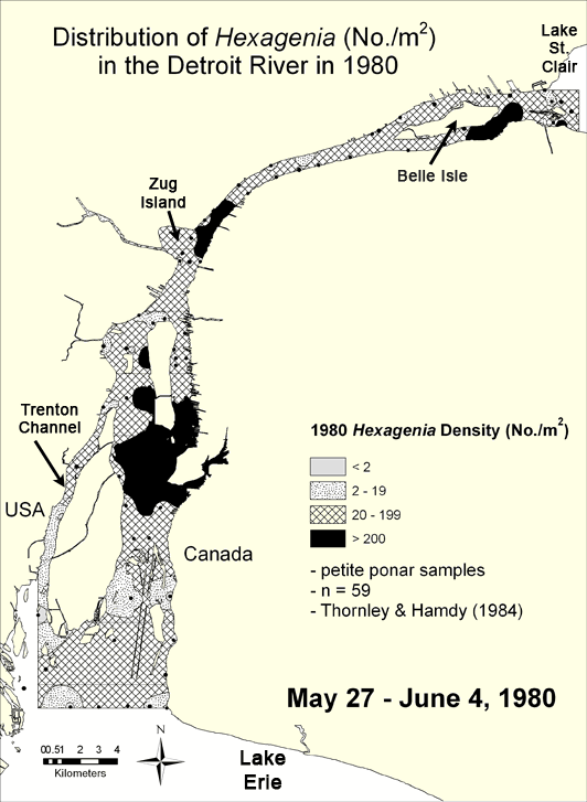
Figure 3. Density of Hexagenia in the Detroit River in 1980 interpolated from data compiled from Thornley and Hamdy (1984). Areas containing fewer than 20 nymphs per square meter indicate either degraded benthic conditions (if sediments are soft) or unsuitable habitat for mayflies (if sediments are hard). Map by Anita Kirkpatrick.
Go to full text of Hexagenia Density and Distribution in the Detroit River
Go to the next map, Distribution of Hexagenia in 1991