Detroit River-Western Lake Erie Basin Indicator Project
Detroit River Coastal Wetlands
Background
Wetlands form and exist where water saturation is the dominant factor determining the nature of soil development and the types of plant and animal communities living in the soil and on its surface. Wetlands vary widely because of regional and local differences in soils, topography, climate, hydrology, water chemistry, vegetation, and other factors, including human disturbance. Often called "nurseries of life," wetlands provide habitat for thousands of species of plants and animals.
Coastal wetlands are commonly formed where there is relatively flat land, shallow water, and a barrier to wave and wind action. Wetlands are valuable resources ecologically, recreationally, and aesthetically. Wetland functions and values, often dependent upon wetland type and location, include the following:
- they provide essential breeding, nesting, resting, feeding, and nursery grounds for many fish and wildlife, including endangered and threatened species;
- they stabilize and maintain the water table by retaining water during dry periods and storing excess water during storm and flood conditions;
- they minimize bank and shoreline erosion along rivers and lakes;
- they serve as living filters by removing nutrients and sediments from upland runoff waters that could otherwise pollute lakes and rivers; some function as sites for groundwater recharge, replenishing and purifying the water in aquifers that supply local wells; and
- others provide recreational opportunities, such as hunting, fishing, birding, and hiking.
Status and Trends
Coastal wetlands were extensive along the Detroit River in the 18th century (Manny et al. 1988; Manny 2003). First explorers like Father Hennepin and Antoine Cadillac described the Detroit River as a pristine "paradise" with abundant edible fruits, lush meadows, forests, fish, and wildlife (Manny 2003). In 1815, the river shoreline consisted of contiguous, coastal wetlands up to a mile wide along both sides of the river (Figure 1). Vegetation types included submersed marsh, emergent marsh, wet meadow and shrub swamp, swamp forest, and lakeplain prairie. Since 1815, the Detroit River ecosystem has undergone dramatic changes; fish and wildlife habitats degraded by shoreline and channel modifications, and greatly reduced wetland abundance and quality from historic levels.
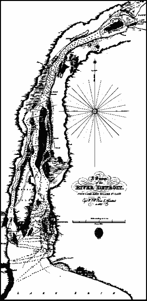
Figure 1. An 1815 map of the Detroit River showing coastal wetlands up to a mile wide along both sides of the river for most of its length, prior to shoreline development (map credit: Association of Canadian Map Libraries & Archives facsimile of an original held in Library & Archives Canada).
The largest habitat change has been encroachment into the river and hardening of the shoreline by the addition of steel sheet piling, concrete breakwalls, and fill material. Analysis of Figure 1 revealed 10.7 square miles (2,768 hectares) of coastal wetlands were present along the Michigan shore of the Detroit River in 1815 (Manny 2003).
Analysis of 1982 Landsat photographs (Figure 2) revealed only a tenth of a square mile (25.5 hectares) of coastal wetlands remained on the Michigan mainland, mostly in the vicinity of Humbug Marsh (Manny 2003). By 1982, more than 99% of the coastal wetlands present in 1815 along the Michigan shore were converted to other land uses. In total, 97% of the coastal wetlands on both sides of the Detroit River have been lost to development. Other losses of habitat included removal of limestone spawning grounds for lake whitefish to create navigation channels, clearing of wooded areas for agriculture, and contamination of the water by waste effluents. In the process, people lost benefits provided by wetlands along the river, such as flood control, protection from shoreline erosion, and removal of nutrients and sediment.
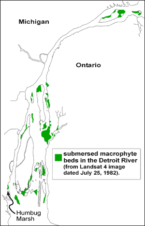
Figure 2. Distribution of wetlands and large submersed macrophyte (wetland plants) beds in the Detroit River, July 1982 (from Manny et al. 1988).
Management Next Steps
Biologists from Canada and the U.S. could establish realistic, achievable, and quantitative targets for the protection and restoration of fish and wildlife habitat, including coastal wetlands, as called for in the U.S.-Canada Great Lakes Water Quality Agreement. These quantitative targets could then be used as benchmarks to measure progress in terms of acres of productive, and uncontaminated habitat, kilometers/miles of natural shoreline, etc., that have been protected in perpetuity (Manny 2003).
Consistent with US Fish and Wildlife Services' "A Conservation Vision for the Lower Detroit River Ecosystem (PDF)," coordinated efforts are needed to protect, in perpetuity, remaining marshes, coastal wetlands, islands, and natural shorelines from development, and to rehabilitate degraded marsh, wetland, island, and shoreline habitats (Metropolitan Affairs Coalition 2001). Additional management actions could include:
- developers and communities could be encouraged to protect remaining wetlands in the Detroit River watershed through adoption of best management practices;
- nonprofit organizations like International Wildlife Refuge Alliance and Friends of the Detroit River could foster volunteer programs that utilize local expertise and interest, along with governmental technical assistance, to protect and enhance coastal wetlands on a watershed scale;
- governments could maintain a publicly accessible, comprehensive coastal wetland inventory that tracks changes in total wetland area;
- communities and private land owners could further use soft engineering techniques on river shoreline redevelopment projects; and
- regulatory agencies could more adequately enforce wetland protection laws and stop the encroachment of development into flood plains.
Research/Monitoring Needs
There is a need to increase research and monitoring programs to quantify wetland losses, establish cause-and-effect relationships, evaluate and select appropriate wetland rehabilitation techniques, and quantify beneficial wetland functions (Tulen et al. 1998). In essence, wetland restoration and conservation projects could be treated like adaptive management experiments that explicitly link research/monitoring with restoration and management of wetlands. Further, available data on ways to protect and enhance wetland ecological functions need to be pooled and synthesized to sort out the most successful tools. For example, we could:
- assess the quality of wetland habitats for production of fish and wildlife to better rank candidate sites for wetland protection and enhancement;
- describe and characterize biodiversity in Detroit River coastal wetlands, and habitats they provide for young fish and wildlife; and,
- quantify economic, social, and ecological benefits resulting from wetland restoration and conservation projects.
References
- Manny, B.A. 2003. Setting priorities for conserving and rehabilitating Detroit River habitats. In, Honor Our Detroit River, Caring for Our Home. J.H. Hartig (Editor), pp. 79-90, Cranbrook Institute of Science, Bloomfield Hills, Michigan.
- Manny, B.A., T.A. Edsall, and E. Jaworski. 1988. The Detroit River, Michigan: An Ecological Profile. U.S. Fish and Wildlife Service, Biological Report 85 (7.17).
- Metropolitan Affairs Coalition. 2001. A Conservation Vision for the Lower Detroit River Ecosystem. Detroit, Michigan.
- Tulen, L.A., J.H. Hartig, D.M. Dolan, and J.J.H. Ciborowski. 1998. Rehabilitating and Conserving Detroit River Habitats. Great Lakes Institute for Environmental Research, University of Windsor, Windsor, Ontario, Canada.
- W.F.W. Owen, "A Survey of the River Detroit from Lake Erie to Lake St. Clair", London, 1828. Reproduced from an original in the National Map Collection, Public Archives of Canada, as Association of Canadian Map Libraries Facsimile Map Series No.20.
Contact Information regarding Detroit River Coastal Wetlands
Bruce Manny
U.S. Geological Survey, Great Lakes Science CenterE-mail: bmanny@usgs.gov