Detroit River-Western Lake Erie Basin Indicator Project
Lake Erie Water Levels
Background
Lake Erie water levels change on short-term (daily and seasonally) and on long-term scales (over years and decades). The longer-term levels are determined by changes in the net supply of water received from the watershed and the upper Great Lakes on a seasonal and annual basis. Storm surges and seiche events (long waves that will move back and forth as they reflect off the opposite ends of the basin) cause changes on a daily or weekly basis (Lee et al. 1996). Historically, the natural water level of the lake has varied over a range of about 2 meters (6 feet) (Lenters 2001; Quinn 2002; Lofgren et al. 2002) and the lake level has tended to cycle through highs and lows over 30-year periods (Figure 1). High-water periods were recorded in Lake Erie in the 1950s and 1980s-1990s, while low-water periods have occurred in the 1930s and 1960s.
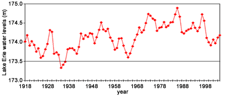
Figure 1. Average annual Lake Erie water levels (International Great Lakes Datum 1985), 1918-2005. The line at 173.5 represents low water datum (International Great Lakes Datum 1983) (United States Army Corps of Engineers, Detroit District, Engineering and Technical Services, Great Lakes Hydraulics and Hydrology Office, 477 Michigan Ave., Detroit, Michigan 48226).
Changing water levels and the resulting shifts in the location of the shoreline and the littoral zone have an important impact on structure, function, and productivity in aquatic systems (Chubb and Liston 1985). Given the relatively flat topography associated with Lake Erie, Lake St. Clair, and associated connecting channels, large expanses of shoreline areas typically become inundated and/or exposed when the lake level changes. Changes in surface water, water exchange, and the ability of fish to move between coastal wetlands, embayments, and the open lake are directly related to the size, timing, duration, frequency, and rate of change of these fluctuating water levels (S.D. Mackey, pers. Comm.). One factor that may have an impact on long-term changes of water levels in Lake Erie, Lake St. Clair and connecting channels is global climate change. Most Global Circulation Models predict that reductions in precipitation, an increase in evaporation, and less ice cover will lead to lower Lake Erie water levels (Lofgren et al. 2002).
Status and Trends
Lake Levels
The rate of decline in annual water levels in 1998-1999 was similar to that seen in the early 1930s, which was the period that established historic low-water levels (Figure 1). Lake Erie water levels have rebounded slightly to 174.2 meters until 2005. Through July 2006, Lake Erie water levels were slightly below those seen in 2005. In May 2007 Lake Erie water levels were slightly above those seen in May 2006. Projections for June-December indicated that lake levels were expected to be at or below (by 0.3 m) mean lake levels in 2007.Even though there is considerable uncertainty as to the impact of global climate change, a decline in Lake Erie water levels over the next several decades, regardless of cause (e.g., water withdrawals, diversions, modifications to connecting channels, or global climate change) will create new, natural shorelines. For example, the best estimates of the effects of global climate change over the next 70 years predict a 1-2 meter (3-6.5 foot) decline in water levels of Lake Erie (Lofgren et al. 2002; Mortsch and Quinn 1996). A 1.5-meter drop in Lake Erie's water level from the 1992 level was expected to result in a 4% reduction in the surface area of the western basin and a 20% reduction in the volume of water in the western basin of Lake Erie. The shoreline would move lakeward by distances of less than 1 km to as much as 6 km (Lee et al. 1996).
Currently, the western basin shoreline of Lake Erie is highly altered. More than 85% of the southwestern shoreline has been hardened over the past three decades (Ohio Department of Natural Resources, Geological Survey, unpublished data). As water levels decline, the shoreline will recede lakeward and the existing shoreline structures will become exposed in many locations. The lower water levels could hydraulically isolate many high-quality wetland and estuarine areas, which provide spawning, nursery, and forage habitat for Lake Erie and Lake St. Clair fish communities. There are many diked wetlands along portions of southwestern Lake Erie. If the desire is to maintain water levels in them, Lake Erie water would have to be pumped over distances of up to a kilometer.
A 1.5-meter decline in lake levels will significantly affect Sandusky Bay. Most areas will become less than 1 meter deep and may become colonized by submerged aquatic plants (Figure 2). Continuing development pressures threaten newly exposed areas, resulting in degradation and the risk of permanent loss of these critical fishery habitats and associated biodiversity, as well as a loss of productive capacity.
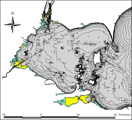
Figure 2. Western Lake Erie projected with 1-m decline in water levels (IGLD 1985) showing areas that will uncover with a 1 meter decline and those that will be less than one meter in depth, and have the potential for establishing submerged aquatic macrophytes. Bathymetric 1-m contour intervals are shown (adapted from National Geophysical Data Center 1998).
Moreover, reduced water levels will alter nearshore littoral (shallow water) and sub-littoral habitats, permanently altering benthic and fish community structure throughout Lake Erie and Lake St. Clair. The effects of lower water levels may also fundamentally affect seasonal timing and connectivity, food web dynamics, and the distribution, structure, composition and abundance of fish communities in Lake Erie, Lake St. Clair, and associated connecting channels (Casselman 2002; Kling et al. 2003). For example, a decrease in total water volume could lead to greater spatial overlap between predators and prey leading to greater loss of young fish to their predators. Changes in lake levels may also alter the hydrodynamic environment. Altered lake currents can modify habitat by changing substrate compositions, circulation patterns, and nutrient dynamics. This would lead to the establishment of new plant and animal assemblages in some places, but may cause their elimination in other locations. The permanent loss/change in the distribution of existing critical wetland, estuarine, and nearshore habitats could have potential long-term detrimental consequences for Lake Erie and Lake St. Clair fisheries and fish communities.
However, suitable planning could create the potential to reestablish some new connected coastal features with associated submerged and emergent aquatic vegetative communities outside of altered shorelines. This would present an opportunity for fish and wildlife managers, as well as the general public, to offset some of the existing wetlands that are expected to be lost if lake levels decline to the extent predicted (Lee et al. 1996)
Fish Community
Changes in both lake level and thermal regime could have significant impacts on the fish community of western Lake Erie and Lake St. Clair. Lower lake levels could potentially affect the amount of habitat available for cold- and cool-water species and limit their production.If lower lake levels resulted in development of a natural (unhardened) shoreline, this could potentially have a significant positive impact on plant-loving species such as northern pike (Esox lucius), muskellunge (Esox masquinongy), and largemouth bass (Micropterus salmoides), particularly if subsequent submersed vegetation accompanies these changes. The waters of western Lake Erie have become clearer over the last ten years (perhaps due to activities of zebra mussels) and the Lake Erie fish community may currently be responding to these recent changes in habitat (and possibly the warming thermal regime). Western basin bottom trawling has been conducted to track the fish community in Ohio waters of Lake Erie each year since 1969. Bottom trawling programs are not designed to specifically assess the Lake Erie nearshore fish community. However, by-catch information from trawls can tell us about trends in the nearshore fish community.
In nearshore areas (places where water is < 6 meters deep) there have been dramatic shifts in species composition and abundance since 1978 (Figure 3). In the late 1970s and early 1980s, catches of centrarchids (which include sunfishes, crappies, smallmouth and largemouth bass) in bottom trawls were dominated by white crappie (Pomoxis annularis), a more tolerant centrarchid species that is not associated with submersed aquatic macrophytes. More recently (2002-2005), catches of plant-loving centrarchids have generally doubled, and are dominated by pumpkinseeds (Lepomis gibbosus) and bluegill (Lepomis macrochirus). These changes are likely associated with declining lake levels, clearer and warmer water, and a resurgence in submersed aquatic macrophytes in many of the bays and harbors around Lake Erie.
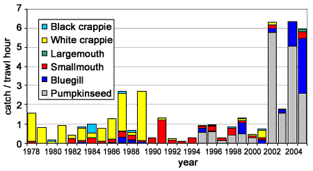
Figure 3. Catch/trawl hour of selected nearshore fishes from Ohio Department of Natural Resources, Lake Erie western basin trawling surveys, May-September, 1978-2005. Nearshore was defined as waters < 6 m in depth.
Management Next Steps
The nearshore fish community in Lake Erie is managed by a cooperative and collaborative process of the Great Lakes Fishery Commission's Lake Erie Committee (LEC) member jurisdictions. This culture of collaboration includes fisheries management agencies, land use planners, land management agencies, and other organizations, and is critical to the proper management of the Lake Erie nearshore fish communities. The LEC has recognized the significance of lake level changes in two important documents – the Fish-Community Goals and Objectives for Lake Erie (Ryan et al. 2003) and the Lake Erie Environmental Objectives (Davies et al. 2005). The LEC has also written a position statement outlining some recommendations for first management steps with respect to changes in lake levels.
The following are the Lake Erie Committee's goals and objectives that are relevant to the fish community with respect to lake level changes and climate change as described in the Fish-Community Goals and Objectives for Lake Erie (Ryan et al. 2003):
- secure a balanced, predominantly cool water fish community with walleye as a key predator in the western basin, central basin, and nearshore waters of the eastern basin, characterized by self-sustaining indigenous and naturalized species that occupy diverse habitats, provide valuable fisheries, and reflect a healthy ecosystem; and
- maintain nearshore habitats that can support high quality fisheries for smallmouth bass, northern pike, muskellunge, yellow perch, and walleye.
- recognize and anticipate natural water level changes and long-term effects of global climate change and incorporate them into management decisions;
- restore natural coastal systems and nearshore hydrological processes;
- restore submerged macrophyte communities in estuaries and embayments and protected nearshore areas; and
- halt cumulative incremental loss and degradation of fish habitat and reverse, where possible, loss and degradation of fish habitat.
- promote general recognition that protection and restoration of coastal land-margin ecosystems because it is crucial to ecosystem rehabilitation and achievement of Environmental Objectives (Davies et al. 2005) and Fish-Community Goals and Objectives (Ryan et al. 2003);
- develop and use predictive models to quantify changes in habitat in response to changing water level regimes, identify existing and future habitat areas requiring protection and restoration, and identify future habitat areas that can be enhanced based upon changing water level regimes;
- once identified, develop and implement conservation and protection actions to protect potential refugia, transitional, and newly created habitats in coastal and nearshore areas from anthropogenic modification and/or degradation; and
- adopt a proactive approach to fisheries that recognizes and anticipates potential long-term changes in water level and thermal conditions resulting from global climate change.
Research/Monitoring Needs
To help ensure maintenance and restoration of the nearshore Lake Erie fish community, a number of areas need further research and monitoring:
- understand how lower water levels will change basin and connecting channel configurations and flows; there is a special need for high resolution bathymetric maps in nearshore waters;
- predict how lower water levels will alter the distribution of critical fisheries habitat, fish recruitment, and fish community structure in Lakes Erie and St. Clair;
- predict and assess the future location and extent of essential coastal, nearshore, and benthic habitats in response to varying lake level and thermal regimes and likely consequences for the long-term sustainability of the food web and fish community; and
- coordinate nearshore fish and habitat monitoring programs across the Lake Erie basin.
References
- Casselman, J.M. 2002. Effects of temperatures, global extremes, and climate change on year-class production of warmwater, coolwater and coldwater fishes in the Great Lakes basin. In Fisheries In a Changing Climate, ed. N.A. McGinn, pp. 39-60. American Fisheries Society Symposium 32. Bethesda, Maryland.
- Chubb, S., and C.R. Liston. 1985. Relationships of water level fluctuations and fish. In Coastal Wetlands, eds. H.H. Prince and F.M. D'Itri, pp. 121-140. Chelsea, MI: Lewis Publishers, Inc.
- Davies, D.H., B. Haas, L. Halyk, R. Kenyon, S. Mackey, J. Markham, E. Roseman, P. Ryan, J. Tyson, and E. Wright. 2005. Lake Erie Environmental Objectives. Great Lakes Fishery Commission, Ann Arbor, MI.
- Kling, G.W., K. Hayhoe, L.B. Johnson, J.J. Magnuson, S. Polasky, S.K. Robinson, B.J. Shuter, M.M. Wander, D.J. Wuebbles, D.R. Zak, R.L. Lindroth, S.C. Moser, and M.L. Wilson. 2003. Confronting Climate Change in the Great Lakes Region: Impacts on our Communities and Ecosystems. Union of Concerned Scientists, Cambridge, Massachusetts, and Ecological Society of America, Washington, DC.
- Lee, D.H., R. Moulton, and D.A. Hibner. 1996. Climate Change Impacts On Western Lake Erie, Detroit River, and Lake St. Clair Water Levels: Great Lakes – St. Lawrence BasinProject Report, Environment Canada and NOAA, GLERL Contribution #985.
- Lenters, J.D. 2001. Long-term trends in the seasonal cycles of Great Lakes water levels. Journal of Great Lakes Research 27(3):342-353.
- Lofgren, B.M., F.H. Quinn, A.H. Clites, R.A. Assel, A.J. Eberhardt, and C.L. Luukkonen. 2002. Evaluation of potential impacts on Great Lakes water resources based on climate scenarios of two GCMs. Journal of Great Lakes Research 28:537-554.
- Mackey, Scudder D., Habitat Solutions, 37045 North Ganster Road. Beach Park, Ill. 60087. Personal Communications.
- Mortsch, L.D., and F.H. Quinn. 1996. Climate change scenarios for Great Lakes Basin ecosystem studies. Limnology and Oceanography 401:903-911.
- National Geophysical Data Center. 1998. Bathymetry of Lake Erie and Lake Saint Clair. In World Data Center for Marine Geology and Geophysics Report #MGG-13, eds. L.A. Taylor, P. Vincent, and J.S. Warren. National Geophysical Data Center. Boulder, CO.
- Quinn, F.H. 2002. Secular changes in Great Lakes water level seasonal cycles. Journal of Great Lakes Research 28:451-465.
- Ryan, P.A., R. Knight, R. MacGregor, G. Towns, R. Hoopes, and W. Culligan. 2003. Fish-Community Goals and Objectives for Lake Erie. Great Lakes Fishery Commission Special Publication 03-02.
Contact Information regarding Lake Erie Water Levels
Jeff Tyson
Ohio Department of Natural ResourcesDivision of Wildlife
E-mail: jeff.tyson@dnr.state.oh.us
Jan Ciborowski
Department of Biological SciencesUniversity of Windsor
E-mail: cibor@server.uwindsor.ca