Detroit River-Western Lake Erie Basin Indicator Project
Water Clarity in Western Lake Erie
Background
Public alarm about Lake Erie's water quality began in the 1960s with the realization that the lake no longer looked as clean as it should have. Because of the algal blooms caused by accelerated eutrophication (see Algal Blooms in Western Lake Erie), the water at times looked green and opaque. Transparency or clarity of lake water helps determine perceived value of the water. Clear water allows fish and bottom structures to be seen and appears attractive, whereas opaque water hides in-water features and looks dirty and unattractive. Clear water allows the growth of aquatic macrophytes that create fish habitat and provide food. Clarity can be affected by the presence of abiotic particles such as clay or other soil fractions derived from watershed erosion; these may be resuspended by waves and currents in the lakes. Too much sediment in the water is even toxic to fish as they have to spend too much time clearing their gills. Biotic particles such as algae also contribute to turbidity. In shallow waters like western Lake Erie, turbidity is caused by a combination of sediment or soil and algae, but in deeper offshore areas, the majority of the turbidity is caused by algae.
The western basin of Lake Erie, with a typical depth of 10 meters, is shallow enough to have dramatic wind/wave driven sediment resuspension, and at the same time a considerable algal biomass. Rivers can also influence water clarity as shown by the areas around the mouths of the Maumee and Detroit rivers. There is no one measure of turbidity that can separate these two causes. Despite this problem, only one common measuring device has historically been used.
Status and Trends
he Secchi disk is a flat black and white disk that is lowered through the water on a rope which has markings to determine the depth. The disk eventually disappears at a depth determined by water turbidity and the depth is noted as transparency or Secchi depth. The Secchi disk was developed by Pietro Angelo Secchi (1818-1878), a Jesuit Italian astrophysicist, and has a long history of use in oceanography and limnology. Some of the best aspects of its use is its long history and the fact that nonscientists can visualize it and easily interpret statements such as "the Secchi disk disappeared in 1 meter of water" to mean the water was quite turbid and unattractive.
The relationship between transparency and trophic status has been summarized by Carlson (1977) as ranges of Secchi transparency corresponding to trophic state:
Oligotrophic: 4-8 meters
Mesotrophic: 2-4 meters
Eutrophic: 0.5-2 meters
Secchi disk depth data are available from western Lake Erie from the late 1960s to the early 2000s (Figure 1). These data show a wide variation of results. Each point with error bars represents measurements in a summer month. Episodic winds and algal blooms cause high variability of Secchi data, as can be seen by the wide spread of the data around each mean dot. According to the trophic scale, the conditions are largely still in the eutrophic to mesotrophic range. It was thought that the water clarity would change with decreased nutrient loads (see Phosphorus Discharges from the Detroit Wastewater Treatment Plant). However, although the phosphorus loads stabilized at low levels in the early 1980s, the water clarity data didn't begin to change until the late 1980s and early 1990s. The increasing tendency for higher values coincided with the invasion of zebra mussels (and quagga mussels) that began around 1988. The zebra mussels filter the water and thus, in the shallow western basin, are able to render the water more transparent. At the same time, benefits of the nutrient reductions probably occurred, but were confused by the effects of the mussels. Recent data show variability due to sediment resuspension and algal blooms so that scientists and managers still do not have a good understanding of the causes and changes in water clarity.
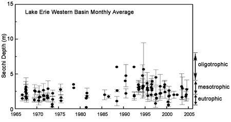
Figure 1. Secchi disk depth data from Canadian sources (from Charlton and Milne 2004).
Management Next Steps
Continued emphasis should be placed on controlling inputs of phosphorus, especially from nonpoint sources. In addition, management emphasis should be placed on stopping the introduction of invasive aquatic species.
Research/Monitoring Needs
Using Secchi transparency or other electronic means of measuring light attenuation in the western basin is not easy. Algal blooms can start in the Maumee River which flows into Lake Erie. High nutrient loads occur in the western flow of the Detroit River, but relatively clean water prevails on the eastern flow. Sediment resuspension can be localized, as well as seasonal. To sample all of these variations in space and time would require many samples from ships. A solution to this problem is remote sensing from satellites.
The Sea-viewing Wide Field-of-view Sensor (SeaWiFS), in orbit since 1997, provides aquatic color imagery suitable for the study of water quality parameters such as phytoplankton pigments (chlorophyll), mineral suspended particulates, and dissolved organic matter (McClain et al. 2004). With daily observations over the Great Lakes region at a ground resolution of 1 km, SeaWiFS data enable trends in water quality parameters such as clarity to be identified and monitored, providing significant advantages over ground-based monitoring programs in terms of spatial and temporal coverage and cost-efficiency.
To summarize, water clarity results from a combination of biotic and abiotic particles in water. Generally, clarity that would allow a Secchi disk to be seen at a depth of 3 meters would be considered adequate by many people. Research is warranted on newer remote sensing technologies that offer a means of monitoring water clarity with better resolution in space and time than is possible with conventional shipboard methods.
References
- Carlson, R.E. 1977. A trophic state index for lakes. Limnology and Oceanography 22:361-369.
- Charlton M., and J. Milne. 2004. Review of thirty years of change in Lake Erie water quality. NWRI Environment Canada Contribution No. 04-167.
- McClain, C.R., G.C. Feldman, and S.B. Hooker. 2004. An overview of the SeaWiFS project and strategies for producing a climate research quality global ocean bio-optical time series. Deep Sea Research II 51:5-42.
Contact Information regarding Water Clarity in Western Lake Erie
Murray Charlton
Environment CanadaNational Water Research Institute
E-mail Address: Murray.Charlton@ec.gc.ca
Caren Binding
Environment CanadaNational Water Research Institute
E-mail Address: Caren.Binding@ec.gc.ca