Detroit River-Western Lake Erie Basin Indicator Project
Contaminants in Western Lake Erie Sediments
Background
Over the past century, discharges of liquid and solid waste from industrial, agricultural and domestic sources have introduced a multitude of toxic substances into the waters of the Great Lakes. The presence of these toxics can adversely impact Great Lakes wildlife, biodiversity and aquatic ecosystems. Many of these contaminants bonded to the particles suspended in water, which are subsequently deposited in open lake areas based on their size and the speed of the current. Accumulation of these particles in successive layers constitutes a historical record of the natural and anthropogenic events that have shaped the environment in the watershed. Therefore, it is important to understand and assess the extent of the contamination in sediments.
Environment Canada, together with collaborating agencies, routinely conduct Great Lakes surveys to measure the occurrence and spatial distribution of toxic substances in order to further our understanding of the role human activities play in releasing these compounds to the environment. The repetition of these surveys also provides information for devising effective strategies to mitigate potentially deleterious health effects. Remedial activities, related to contaminant control, routinely address sources. The reduction of point source discharges is often followed by a decrease in the amount of contaminant in the ambient environment and can be reflected in downstream sediments. The use of sediment contamination as an indicator of contaminant loading is a valuable tool for environmental monitoring. The study of sediment contamination also allows assessment of the success of remedial actions related to the elimination or reduction of contaminant sources. Sediment quality is monitored by analyzing both the deep layer of sediment, considered a trap for toxic substances, and surface sediments, which are examined to characterize recent inputs of particles.
Sediment Quality Assessment Criteria
The chemical quality of sediment is generally assessed by looking at its toxicity to benthic organisms. Two levels are generally employed: a base concentration that produces an effect in organisms (the Threshold Effect Level, TEL), and a concentration that probably produces an effect in organisms (the Probable Effect Level, PEL). These concentrations were established by the Canadian Council of Ministers of the Environment (CCME) and are routinely used by the different stakeholders involved in sediment management activities.
Status and Trends
Lake Erie is surrounded by 17 urban areas and the agricultural sectors of southwestern Ontario, and part of the states of Ohio, Pennsylvania, New York and Michigan. In its western portion, it receives the waters of the Detroit River and Lake St. Clair, whose shores are home to many manufacturing and processing plants.
In 1971, Environment Canada conducted a survey in Lake Erie to characterize the spatial extent of sediment contamination by metals and organochlorine contaminants using surficial sediment samples (Frank et al. 1977, Thomas and Jaquet 1976, Thomas et al. 1976). In addition, the impact of human activities over time was assessed using sediment cores (Kemp and Thomas 1976, Kemp et al. 1976). Sediment levels of metals, including total mercury, lead, zinc, cadmium and copper, were compared to pre-colonial concentrations. The highest total mercury concentrations occurred in the western basin adjacent to the Detroit River; DDT was similarly distributed. Inputs of PCBs were apparent along the southern shore while dieldrin appeared to have sources along both the south and north shores. A western basin core sample indicated that PCBs and other organochlorines began to accumulate in the sediments during the period 1953 to 1958. In general, sediments in the western basin of Lake Erie exhibited high levels of contamination. Sediments in the central and eastern basins exhibited levels intermediate between those in the western basin and lower levels in sediments in Lake St. Clair, which discharges into the Detroit River.
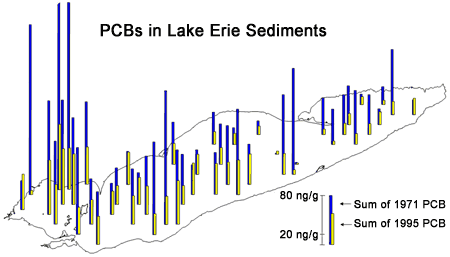
Figure 1. Comparison of Lake Erie surficial sediment total PCB concentrations (ng/g dry wt.) in samples collected in 1971 and 1995. Canadian Sediment Quality Guidelines threshold effect level (TEL) = 34.1 ng/g, probable effect level (PEL) = 277 ng/g.
1971 and 1995 PCB concentrations are higher in the western basin, trending lower toward the eastern basin, and higher along the southern shore of the central basin. 1995 concentrations are, for the most part, considerably lower than 1971 concentrations.
In 1995, Environment Canada revisited 50 of the original 259 sites from the 1971 survey. The 1995 sediment samples, as well as archived 1971 samples, were analyzed for PCBs and other organochlorine pollutants. Encouragingly, the PCB and organochlorine concentrations had decreased considerably from those reported in 1971 (Figure 1 and Figure 2 ). As a follow-up measure, Environment Canada in collaboration with the Ohio Environmental Protection Agency conducted additional Lake Erie surveys in 1997 and 1998 to enable a broader range of analyses for the assessment of current sediment contamination. The surveys provided further documentation of the improvement in sediment contaminant concentrations from the original 1971 survey. In 1971, as in 1997–98, the sediments with the highest mercury contamination occupied the western basin of the lake. Results of the 1997 and 1998 surveys confirmed the initial conclusion that contaminant concentrations had been significantly reduced. Since the 1970s, average mercury concentrations in surface sediment in the lake as a whole fell by about 70%, dropping from 0.61 µg/g in 1971 to 0.190 µg/g in 1997–98. This trend is also evidenced by the profiles of core samples from the three major basins.
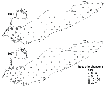
Figure 2. Lake Erie surficial sediment hexachlorobenzene concentrations (ng/g dry wt.) in samples collected in 1971 (top) and 1997 (bottom).
In 1971, as in 1997–98, the sediments with the highest contamination occupied the western basin of the lake. Results of the 1997 and 1998 surveys confirmed the initial conclusion that contaminant concentrations had been significantly reduced. Concentrations range from 0-20+ ng/g dry weight.
Spatial trends in sediment contamination in Lake Erie are similar for a number of compound classes including total PCBs, dioxins and furans, total mercury, and metals. There is a trend towards increasing contamination from the eastern basin to the western basin, and from the northern portion of the central basin to the southern portion of the central basin. Presumably, these trends are influenced by industrial activities in the watersheds along major tributaries including the Detroit River, and areas along the southern shoreline. Other major influences may include prevailing currents, sediment transport and deposition processes, open-lake disposal of dredged material, and remediation of contaminated areas. Environment Canada monitoring of suspended sediment quality in Lake Erie has shown that the western basin continues to be subjected to active loadings of contaminants. The Detroit River has been identified as a primary vector for these contaminants, but potential loadings from other tributaries cannot be discounted. In addition, atmospheric deposition may have contributed to these loadings.
Sediments in some areas of Lake Erie still exceed the strictest Canadian and Province of Ontario Sediment Quality Guidelines as defined by the threshold effect level (TEL) or lowest effect level (LEL), respectively. Exceedences of sediment guidelines are largely restricted to the western basin and the southern portion of the central basin. Exceedences of Canadian Sediment Quality probable effects guidelines (PEL) are most numerous for dioxins and furans (40%) followed by mercury (6%). The Canadian threshold effects guideline (TEL) for PCBs and the Provincial lowest effect guideline (LEL) was exceeded at 52% and 22% of the sites, respectively, in the 1997/1998 surveys. The pollutants identified as exceeding various guidelines, mercury, PCBs and dioxins and furans, are responsible for the fish consumption advisories in Lake Erie. However, the current trend in sediment contamination toward lower concentrations suggests that the strictest criteria for sediment quality in Lake Erie for some contaminants will be eventually achieved (Figure 3).
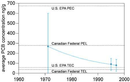
Figure 3. Lake Erie lakewide average PCB concentrations compared to Canadian and U.S. sediment quality guideline values.
PEC (676 ng/g) = Probable Effect Concentration - the concentration at which effects are likely to occur
PEL (277 ng/g) = Probable Effect Level - the concentration at which effects are likely to occur
TEC (59.8 ng/g) = Threshold Effect Concentration - the concentration at which effects rarely occur
TEL (34.1 ng/g) = Threshold Effect Level - the concentration at which effects rarely occur
Management Next Steps
The reduction in sediment contamination in all areas of Lake Erie comes in the wake of regulatory measures implemented by public authorities, particularly binational initiatives. The regulatory measures resulted in the closure of industrial facilities, improvements in industrial processes and water cleanup operations. Indeed, for some years already, Canada and the U.S. have jointly undertaken to reduce discharges of toxics, and to work toward the rehabilitation of contaminated sites through initiatives such as the Great Lakes Water Quality Agreement and the Great Lakes Binational Toxics Strategy. This binational collaboration in reducing discharges, research and monitoring, and working towards virtual elimination of toxics must continue.
Research/Monitoring Needs
Long-term research and monitoring of suspended and bottom sediments in the Detroit River – western Lake Erie corridor must continue, particularly in light of ongoing remediation of areas of contaminated sediment in the lower reaches of the river. Suspended sediments serve as a useful indictor of contaminants entering the open-lake area; sampling downstream of contaminated areas can serve as a useful indictor of the efficiency of remedial activities. Bottom sediments remain a key indicator of the response of the open-lake areas to reductions in contaminant loadings.
References
- C.H. Marvin, M.N. Charlton, E.J. Reiner, T. Kolic, K. MacPherson, G.A. Stern, E. Braekevelt, J.F. Estenik, L. Thiessen, and S. Painter. 2002. Surficial sediment contamination in lakes Erie and Ontario: A comparative analysis. Journal of Great Lakes Research. 28(3): 437–450.
- C.H. Marvin, S. Painter and R. Rossmann. 2004. Spatial and temporal patterns in mercury contamination in sediments of the Laurentian Great Lakes. Environmental Research. 95: 351-362.
- C.H. Marvin, S. Painter, M.N. Charlton, M.E. Fox, P.A. Thiessen. 2004. Trends in spatial and temporal levels of persistent organic pollutants in Lake Erie sediments. Chemosphere. 54: 33-40.
- S. Painter, C.H. Marvin, F. Rosa, T. Reynoldson, M.N. Charlton, M. Fox, P.A. Thiessen and J.F. Eestenik. 2001. Sediment contamination in Lake Erie: A 25-year retrospective analysis. Journal of Great Lakes Research. 27(4): 434–448.
- Canadian Council of Ministers of the Environment. 1999. Canadian Environmental Quality Guidelines. Winnipeg, Manitoba.
- Frank, R.M., Holdrinet, H.E. Braun, R. L. Thomas, A.L.W. Kemp, and J.-M. Jaquet. 1977. Organochlorine insecticides and PCBs in sediments of Lake St. Clair (1970 and 1974) and Lake Erie (1971). Sci. Tot. Environ. 8:205-227.
- Kemp, A.L.W. and Thomas, R.L. 1976. Impact of man's activities on the chemical composition in the sediments of Lakes Ontario, Erie, and Huron. Water, Air, and Soil Pollution. 5:469-490.
- Kemp, A.L.W., Thomas, R.L., Dell, C.I. and Jaquet, J.-M. 1976. Cultural impact of the geochemistry of sediments in Lake Erie. J. Fish. Res. Board Can . 33:440-462.
- Thomas, R.L. and J.-M. Jaquet. 1976. Mercury in the surficial sediments of Lake Erie. J. Fish. Res. Board Can . 33:404-412.
- Thomas, R.L., Jaquet, J.-M., Kemp, A.L.W. and Lewis, C.F.M. 1976. Surficial sediments of Lake Erie. J. Fish. Res. Board. Can. 33:385-403.
Contact Information regarding Contaminants in Western Lake Erie Sediments
Chris Marvin
Research ChemistEnvironment Canada
E-mail: Chris.Marvin@ec.gc.ca