Detroit River-Western Lake Erie Basin Indicator Project
Lake Erie Ice Cover
Background
Winter ice cover on Lake Erie affects the amount of heat and moisture transferred between the lake and the atmosphere. During winter, ice and snow can decrease the amount of light available below the ice surface for photosynthesis. In the absence of an ice cover, winds can cause mixing of the water column and in some cases re-suspend bottom sediment. If ice cover is present, high winds can cause rafting of ice that, in some cases, can cause ice scouring along the lake bottom. In the nearshore region, erosion can occur when ice attached to the shore is moved by winds. Ice cover also affects lake levels by reducing lake evaporation.
Ice cover can impact the economy by impeding or stopping navigation, interfering with power plants and cooling water intakes, and damaging shore structures. Other potential economic impacts of reduced ice cover could include a longer shipping season, increased evaporation, lower lake levels, increased dredging for navigation, lower ship cargo capacity, reduced winter recreational activities, and loss of critical habitats.
Winter ice formation and seasonal ice cycles have been documented over the past 43 winters through visual observation, radar, and satellites (Figure 1).
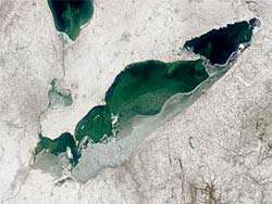
Figure 1. MODIS (NASA) satellite image of Lake Erie for March 12, 1999. The lake is approximately 50% ice covered; note that the north portion of the lake is open water.
Status and Trends
Lake Erie develops an extensive ice cover most winters because, in comparison to the other Great Lakes, it is relatively shallow (mean depth: 19 m), it has a relatively small volume that does not store a lot of heat, and it has sufficiently low fall and winter air temperatures. The Annual Maximum Ice Cover (AMIC) is a useful indicator that measures the maximum lake surface area covered by ice each year (Assel et al. 2003). AMIC was greater than or equal to 80% in 37 of the 43 winters between 1963 and 2005 (Figure 2). Extremely mild winters occurred in 1983 (AMIC 41%), 1991(AMIC 38%), 1998 (AMIC 5%), and 2002 (AMIC 14%). These winters contributed to the observed downward trend in the 4-year AMIC running average.
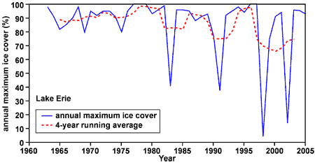
Figure 2. Lake Erie annual maximum ice cover for winters 1963 – 2005. Mild winters in 1983, 1991, 1998, and 2002 contribute to the observed downward trend in the 4-year AMIC running average.
The western basin of Lake Erie, i.e. the lake approximately west of a diagonal line from Point Pelee to Sandusky Bay, is relatively shallow and that would favor winter ice formation. Western basin January through March average ice cover (Figure 3) was calculated from daily averages (Assel 2004). This 3-month average ice cover varied from approximately 5% to 90% over the winters of record. The two extremely mild winters, 1998 and 2002, are noteworthy as they set new record lows for average winter ice cover (Assel 2005). The western basin was virtually free of any significant ice cover in 1998 and, with the exception of portions of January, the same was true for 2002. The 4-year running average ice cover (Figure 3) shows a maximum value in the late 1970s followed by a general downward trend thereafter. Winter 2006 also had below normal ice cover. Extensive December ice cover was lost by mid-January due to mild air temperatures. Cold air temperatures brought limited new ice formation the last ten days of February. That ice cover was lost the first week of March. What are the ecosystem consequences of the anomalously low ice cover during the winter of 2006?
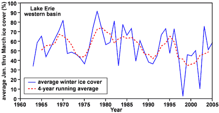
Figure 3. Western basin 3-month averaged ice cover. Ice cover prior to 1972 is modeled using a freezing degree-day ice cover model. The 4-year moving average of the 3-month averaged ice cover is plotted on the third year.
Management Next Steps
Climatic warming may cause a dramatic reduction in ice cover with as yet unknown consequences to Lake Erie and the other Great Lakes. The combined influence of climatic warming and invasive species on Lake Erie needs to be evaluated in order to develop better tools for decision makers and managers. This evaluation should include a historical analysis of changes in the winter ecosystem relative to changes in ice cover.
Research/Monitoring Needs
The current remote sensing (satellite and aerial reconnaissance) program to observe and document Great Lakes ice cover should be continued and expanded for use in the development, calibration, and verification of lake ice and winter lake bio-geochemical models.
The impact of ice on lake plants and animals is not well known because of limited under-ice observations of plants and animals, and the physical factors that affect them. A long-term winter field program of surface and subsurface observations is recommended in order to develop a better understanding of the physical and biological characteristics and processes of the winter aquatic ecosystem.
References
- Assel, R. A. 2005. Classification of Annual Great Lakes Ice Cycles: Winters of 1973–2002. J. Climate. 18: 4895-4905.
- Assel, R. A. 2004. Lake Erie ice cover climatology -- basin averaged ice cover: winters 1898-2002. NOAA Technical Memorandum GLERL-128. NOAA, Great Lakes Environmental Research Laboratory, Ann Arbor, MI, 15 pp. (February 2006).
- Assel, R.A., K. Cronk, and D.C. Norton. 2003. Recent trends in Laurentian Great Lakes ice cover (PDF). Climatic Change. 57:185-204. (Feburary 2006).
Contact Information regarding Lake Erie Ice Cover
Raymond Assel
Scientist EmeritusNOAA Great Lakes Environmental Research Laboratory
E-mail: Ray.Assel@noaa.gov