Detroit River-Western Lake Erie Basin Indicator Project
Detroit River Coastal Wetlands
Background
The area that drains to a common waterway, such as a stream, lake, estuary, wetland, and aquifer is a watershed. The Rouge River watershed in southeast Michigan (Figure 1) is largely urbanized, spans approximately 1,134 square kilometers (438 square miles), is home to over 1.5 million people in 48 communities and three counties, and is a tributary to the Detroit River. From the very beginning, the Rouge River has been recognized for its strategic location and beneficial uses. Native people settled along the shores of the river to use it as a transportation route, take advantage of the water supply, and benefit from the incredible fishing and hunting (Bean et al. 2003). In 1701, the French built their fort and established the first permanent settlement in the region. Later in the eighteenth century, gristmills would be established on main forks in the river and shipyards established on the lower river. The lower Rouge River was dredged in the early 1900s to accommodate shipbuilding and the rapidly growing automobile industry. Henry Ford consolidated automobile manufacturing operations into one geographical area to create efficiencies and synergies, turning Zug Island and the lower Rouge River into the heartland of the Industrial Revolution. The Rouge River became the recipient of waste oil and other industrial pollutants.
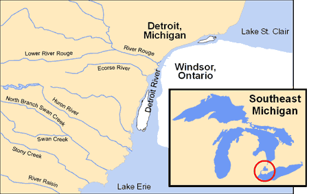
Figure 1. Rivers of Southeast Michigan.
Mass production of automobiles and subsequent intense urbanization of the Rouge River watershed placed additional stresses on the river, including storm water runoff and other diffuse sources. Chief among these were sanitary sewer overflows and combined sewer overflows (CSOs) that discharged untreated sanitary waste into the river during wet weather conditions. A study of the Rouge River in the early 1970s (Jackson 1975) reported, "approximately 40 miles of the Rouge River were characterized by very poor water quality as evidenced by a macroinvertebrate community dominated by animals tolerant of severely polluted waters. The principal contaminants at that time were raw sewage and inorganic sediment entering the river via combined and/or storm sewers."
As industrial point sources of pollution were being addressed during the 1960s and 1970s through both federal and state regulatory initiatives, it soon became clear that more would need to be done to address nonpoint sources of pollution (pollution which cannot be traced back to a single origin or source such as storm water runoff, water runoff from urban and agricultural areas, and failed septic systems). The Rouge River was still highly polluted during the 1970s; raw sewage from CSOs and sanitary sewer overflows was being discharged, there were odor problems, and fish were dying. Urbanization of the watershed had significantly increased the impervious surfaces in the watershed resulting in significant increases in the volume and amount of energy in the runoff waters after wet weather events.
CSOs and polluted storm water runoff result in many water quality problems, including extreme flow variations, streambank erosion, flooding, loss of habitat, high bacteria levels, and low dissolved oxygen. Polluted storm water runoff contains bacteria, heavy metals, nutrients, oil, and pesticides. Minimizing the impact of both CSOs and polluted storm water is critical to the restoration of the Rouge River and its impact on the Detroit River.
Dissolved oxygen is an important parameter in defining the health of aquatic ecosystems. When dissolved oxygen concentrations are below 4.0 mg/L, there are potentially adverse impacts on aquatic life. To protect aquatic life, State of Michigan water quality standards specify that dissolved oxygen must be greater than 7 mg/L at all times for streams designated as cold water fisheries and must be greater than 5 mg/L at all times for streams designated as warm water fisheries. All of the Rouge River and its tributaries are designated as warm water streams except for Johnson Creek, which is designated as a cold water fishery.
Therefore, dissolved oxygen levels in the Rouge River have been identified as a key indicator of environmental quality and a key indicator that tracks effectiveness of water pollution control programs. It should be noted that this indicator is important to both the restoration of the Rouge River and its subsequent impact on the Detroit River.
Status and Trends
Many initiatives have taken place in support of forging a holistic approach to watershed management for the Rouge River. The Rouge River Remedial Action Plan (RAP) process began in 1985 with the recognition that state government had the authority to force corrective action, but due to the diffuse nature of the problem and large expense, public awareness and local community commitment, cooperation, and involvement were essential to restoring the Rouge (Bean et al. 2003). The Rouge River Basin Committee was established to work with local governments and stakeholder groups to bring about local ownership of the RAP. All 48 communities in the watershed participated on the Rouge River Basin Committee along with other stakeholders.
The initial Rouge River RAP was completed in 1988. The RAP focused heavily on sanitary sewer overflows and CSOs because approximately 29,526,212 cubic meters (7.8 billion gallons) of combined sewage was being discharged into the Rouge River during rain events annually. It is important to note, however, that although the 1988 RAP recommendations focused on sanitary sewer capacity and CSO control, it also recognized polluted storm water from separated sewers as a significant problem across the entire watershed. In 1992, the Rouge River National Wet Weather Demonstration Project (Rouge Project) was established with funding from the U.S. Environmental Protection Agency to Wayne County's Department of Environment to implement the RAP (Murray 1994). The Rouge Project recognizes that to be cost-effective, pollution problems in the river must be addressed collaboratively by all of the local governments, the counties, and other stakeholders, and with flexibility across the regulatory programs. Decisions should be made and success based on results made in the resource, and/or in creating the capacity to better manage the resource, and not solely on meeting permit compliance requirements and timelines. This comprehensive implementation effort deals with the problems of sanitary sewer overflows, CSOs, and polluted storm water runoff. Regulatory policy, programs and financial institutional arrangements have also been a major effort of the Rouge Project. Outcomes include the State of Michigan's Watershed-Based Storm Water Permit, passage of the Watershed Alliance Act (Public Act 517 of 2004), the establishment of the Alliance of Rouge Communities, and the implementation of a comprehensive monitoring plan for the Rouge River watershed.
For the purposes of this indicator report, it was decided to focus on one of the best long-term indicators of environmental quality – dissolved oxygen levels in two key subwatersheds (Main 3 and 4) of the Rouge River. Main 3 and 4 subwatersheds are located in the lower (most downstream) end of the Rouge River. Consequently, these subwatersheds are the recipient of all the upstream impacts from human activity, and historically have been the portion of the river that has had the poorest water quality. Figure 2 presents the long-term trend for dissolved oxygen in Main 3 and 4 sub-watersheds of the Rouge River. The earliest dissolved oxygen data were from the 1973 study conducted by the Michigan Department of Natural Resources (Jackson 1975). These dissolved oxygen trend data show that the percentage of dissolved oxygen measurements that exceed the 5 mg/L state standard for protection of a warm water fishery has increased from approximately 20% in 1973 to over 80% in recent years. Although there are still violations in this most downstream and heavily impacted portion of the Rouge River watershed, this dissolved oxygen trend documents that substantial improvements are occurring as a result of the watershed restoration measures.
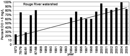
Figure 2. The percentage of dissolved oxygen measurements in Main 3 and 4 subwatersheds of the Rouge River that exceed the Michigan standard of 5 mg/L for protection of a warm water fishery, 1973-2005. A higher percentage means that these subwatersheds more frequently exceed the Michigan dissolved oxygen standard and that dissolved oxygen conditions are improving
It is recognized that many indicators are needed to fully assess the health of the Rouge River watershed. In December of 2005, the Rouge RAP Advisory Council published an update to the Rouge River Report Card. A brief summary of indicator trends from this Rouge River Report Card is presented below:
- 10 of the 18 Rouge River Report Card indicators are "making progress";
- 4 of the 6 pollution control and water quality indicators show that management efforts are "making progress"; none of the 6 pollution control and water quality indicators are "losing ground"; and
- while 5 of the 6 habitat and wildlife indicators are reported as "losing ground," all 6 of the indicators relating to stewardship are reported as "making progress."
Management Next Steps
Key management actions for the Rouge River watershed include:
- complete Phase 2 CSO control projects (planned CSO controls on all remaining combined sewer areas);
- continue sanitary sewer capacity improvements;
- promote the economic importance of the region's "Green" (plants) and "Blue" (waters) infrastructure to encourage adequate public investment in continued restoration and protection efforts;
- ensure sufficient collaboration among the 48 watershed communities, the three watershed counties, the Michigan Department of Environmental Quality, and the U.S. Environmental Protection Agency to secure adequate funding for discharge elimination; and
- sustain the public education and watershed monitoring and restoration activities initiated via the Rouge Project (MIG619000) (Wayne County Department of Environment 2006).
Research/Monitoring Needs
Monitoring is essential for proper watershed management. Priority must be given to ensuring sufficient monitoring to be able to adequately evaluate effectiveness of programs and to make midcourse corrections. Further, research is needed on innovative funding mechanisms for storm water and watershed management in order to maintain the momentum for restoration and protection efforts.
References
- Bean, C.J., J.H. Hartig, and N. Mullett Jr. 2003. Watershed planning and management: The Rouge River experience. In Honoring Our Detroit River: Caring for Our Home, ed. John H. Hartig, pp. 185-198. Bloomfield Hills, MI: Cranbrook Institute of Science.
- Jackson, G. 1975. A biological investigation of the Rouge River, Wayne and Oakland counties, May 17–October 19, 1973. Department of Natural Resources. Lansing, MI.
- Murray, J. 1994. Rouge River Watershed Management: Implementing a Remedial Action Plan (RAP). Proceedings of 67th Annual Conference of the Water Environment Federation. Alexandria, VA.
- Wayne County Department of Environment. 2006. Seventh Annual Report. Certificate of Coverage MIG610040. General Storm Water Permit.
Contact Information regarding Detroit River Coastal Wetlands
Noel Mullett Jr., Technical Projects Coordinator
Wayne County Department of EnvironmentWater Quality Division
E-mail Address: nmullett@co.wayne.mi.us
Patrick Cullen, Department Manager
Wayne County Department of EnvironmentWater Quality Division
E-mail Address: pcullen@co.wayne.mi.us
Dean Tuomari, Department Manager
Wayne County Department of EnvironmentWater Quality Division
E-mail Address: dtuomari@co.wayne.mi.us